

Water Stewardship
What We Do:
The Water Stewardship program at YRITWC is dedicated to the ongoing health of the water in the Yukon River Watershed and its Indigenous people. We rely heavily on both the scientific method and traditional knowledge passed down through generations. The Water Stewardship program works closely with community members through the observation network and outreach strategies. One example is through training local technicians for data collection in their community. If you would like to participate in water data collection in your community, we welcome your call!
Indigenous Observation Network (ION)
The Indigenous People of the Yukon River Basin have been forming an observational 'baseline' for thousands of years. Until the modern age, the 'best technology' to make observations was our experience of the land. The best means of organizing this 'baseline' data was by passing down stories generated from experience. Today, the YRITWC facilitates the integration of stories and experiences with scientific environmental monitoring. Since 2006 the YRITWC and Yukon River Basin communities have partnered with the United States Geological Survey (USGS) to collected high quality environmental data about the water and the land. This work is made possible only through the development of partnerships with communities along the river and would not be possible without the dedication of community technicians, the staff of the YRITWC Water Stewardship program, and the support of USGS.
GIS & Mapping
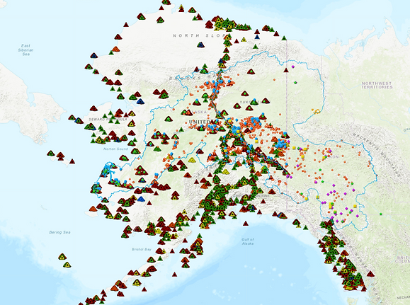
IGAP Map
This interactive map, created by YRITWC, characterizes human and natural activity in the Yukon River Watershed with an emphasis on potential threats to water quality. It is transboundary and includes federal, state, territory, and academic data. It is intended to provide a watershed-scale view of activities with relevance to water quality. It includes information on the Indigenous Observation Networks (ION) sample locations, Chinook salmon spawning areas, permitted toxic releases from the EPA, pipelines, active oil and gas areas, dams, mining activity, wastewater treatment facilities, solid waste sites, and impaired waters.
Click here: http://yritwc.maps.arcgis.com/apps/MapTools/index.html?appid=00de04c6a14e41abbf7b4949bc2a1206 for additional information.
With support provided by the U.S. Environmental Protection Agency
For more information about these maps, please contact Edda Mutter at emutter@yritwc.org
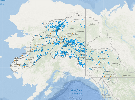
Mining in the Yukon River Watershed
Click on the photo to access an interactive map of mining activity within the Yukon River Watershed or visit https://goo.gl/rQqXCt
Click on blue points for more information about the mine, including external links. Use the filter to view mines by their status, and type the name of the mine in the search box to find it on the map.
Map includes information compiled from the Mineral Resource Data System a worldwide collection of the best available data, https://mrdata.usgs.gov/mrds/ maintained by the USGS, last up-dated in 2011, and Alaska Dept. of Natural Resources State Geo-Spatial Clearinghouse http://www.asgdc.state.ak.us/#911 which is continuously updated, Exploration data for the Yukon Territory is from Yukon Government, Energy, Mines and Resources, http://www.emr.gov.yk.ca/mining/mapsdatapubs.html, last up-dated in 2016. Historic prospects, that were not mined and are currently inactive were excluded from the dataset.
Additionally, the mine disturbance footprint is from 'Geist, M., M. Aisu , P. Lema & E. J. Trammell. 2017. Spatial estimates of surface mining footprints in northwest boreal ecoregions of Alaska and Canada.' at http://accs.uaa.alaska.edu/landscape-ecology/northwest-boreal-anthropogenic-footprint/
With support provided by the Lannan Foundation
With support provided by the Lannan Foundation
Communities Involed
Arctic Village
Anvik
Allakaket
Eagle
Gwichyaa Gwich'in Tribal Gov.
Council of Athabascan Tribal Gov.
Kotlik
Hooper Bay
St. Michaels
Emmonak
Tanacross
Nenana
Chuloonawick
Circle
Ohogamuit Traditional Council
Pilot Station
Ruby
Louden Traditional Council
Koyukuk
Iqurmiut Tribal Council
Yupiit of Andreafski
Stebbins
Venetie
Carcross Tagish First Nation
Nacho Nyak Dun First Nation
Kwanlin Dun First Nation
Little Salmon/Carmacks First Nation
Ta'an First Nation
Taku River Tlingit First Nation
Teslin Tlingit Council First Nation
Tr'ondek Hwech'in First Nation